Route to a hydrant
|
Note: To route to a hydrant, you must have already defined a starting point for the route in one of these ways.
|
-
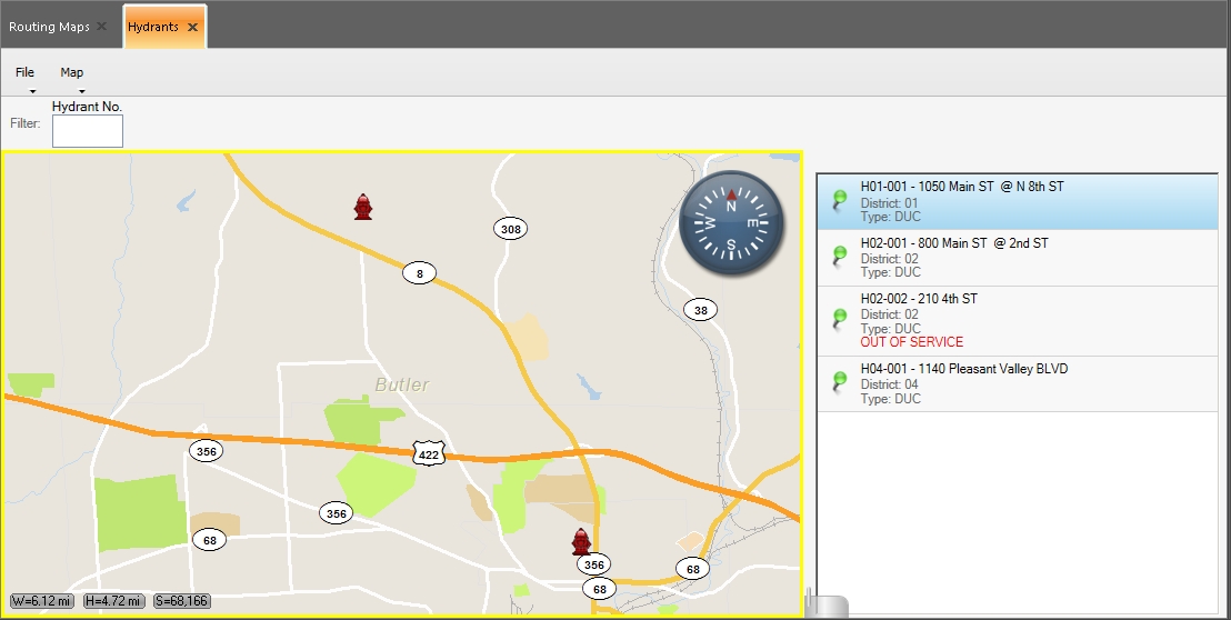
(If you have not done so already) Choose Go → Open → Open Hydrants.
The Hydrants tab appears, displaying a map, a list of hydrants to the right of the map, and a push-pin indicating the location of the hydrant selected in the list. Two additional menus, File and Map, appear on the tab above the map.
- From the hydrant list to the right of the map, select the hydrant you want to route to.
-
Choose Map → Route To.
The Routing Maps tab opens, a
Destinationlabel appears on the map below the hydrant push-pin, the route from the starting point to the hydrant you selected appears on the map as a thick blue line, and each turn is identified by a colored dot. The smaller map in the upper right corner of the interface displays the entire route and, if you are using a GPS device, your current location on the route.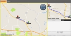
If you manually set the starting point, the turn-by-turn directions pane in the lower right corner displays the message
Not Routing From GPS, and only the address of the hydrant appears in the pane. If you are using a GPS device, the turn-by-turn directions pane populates with additional information.Information on defining a starting point is available in Manually define a starting point for a route. Information on configuring a GPS device with FH Mobile Response is available in Set up GPS communication with FH Mobile Response.