Set initial map zoom distances
You can specify the distance from the Earth to view any new map you add, when no location is known.
Example: You may want new maps to open with a distance high enough from the Earth to display a county and all the towns in it.
You can also specify the distance from the Earth to "zoom" to when a location is known.
Example: You may want to "zoom" to a distance high enough to see a single town or area within the county.
You can also specify the distance from the Earth to use when keeping the map centered on your current location with a GPS unit. This feature requires that you have a GPS configured to work with FH Mobile Response, and that you have enabled tracking of your current location.
Information on configuring a GPS device is available in Set up GPS communication with FH Mobile Response.
Information on keeping a map centered while tracking your current location is available in Keep the map centered when tracking.
Note: You must have purchased FH Mobile Response Premium to set the initial map zoom distances. For information on upgrading from FH Mobile Response Basic to Premium, contact your FH sales representative.
-
Choose Go → Config→ Options.
The Options dialog box appears, displaying the Server tab.
-
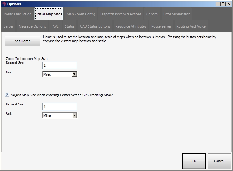
Click the Initial Map Sizes tab.
Basic
Premium
-
Specify the distance from the Earth to view any of the following.
Note: You may want to close the Options dialog box and adjust the current view of the map to reflect the distance from the Earth you want before continuing with the options below.
 Any new map you add, when no location is known
-
Click Set Home.
The current map location and distance from the Earth is used whenever you add a new map.
In addition, if, in the View / Op toolbar on the left side of the interface, you click Zoom To, a new Home button is available in the dialog box that appears.
If you click the Home button in this dialog box, the current map pans and zooms to the location and distance from the Earth that you defined when you clicked Set Home in the Options dialog box.
A known location
-
Under Zoom To Map Size, in Desired Size, type the specific distance from the Earth you want to view a map location from.
Whenever FH Mobile Response zooms to an incident location or an address, the value in this field is used to determine the zoom distance from the Earth for the map view.
- From Unit, select the type of units the distance should be measured from.
Your current location, with center-screen mode
-
Select or clear Adjust Map Scale when entering Center Screen GPS Tracking Mode, to indicate whether or not you want to use the feature.
FH Mobile Response will zoom to the distance in this field when keeping the map centered on your current location with a GPS unit.
-
In Desired Size, type the specific distance from the Earth you want to view a map location from.
Whenever FH Mobile Response zooms to an incident location or an address, the value in this field is used to determine the zoom distance from the Earth for the map view.
- From Unit, select the type of units the distance should be measured from.
-
- Click OK.