Find a location using latitude and longitude
Latitude and longitude are standard, geographic coordinate values used to locate points on the surface of the Earth. These coordinate values are measured in degrees, and represent angular distances calculated from the center of the Earth. Degrees of latitude and longitude can be further subdivided into minutes and seconds: there are 60 minutes (') per degree, and 60 seconds (") per minute. All these notations locate places on the Earth very precisely.
- Select the tab of the map that you want the location to appear in when you find it.
-
Do one of the following.
- On the Main ribbon, click Find Locations → Latitude Longitude.
- Choose Go → Tools → Find Locations → Latitude Longitude.
- Choose Go → Tools → Routing → Find Locations → Latitude Longitude.
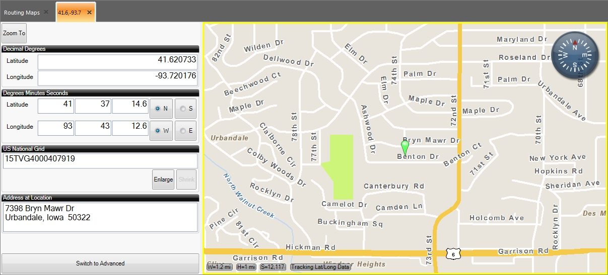
A tab named with a pair of numerical values appears to the left of the map, and contains fields for specifying latitude, longitude, and United States National Grid (USNG) values. The map you selected initially displays a location icon at a random location.

- Under Decimal Degrees, in Latitude and Longitude, enter the latitude and longitude values that describe the location you want to find.
- (If known) Under Degrees Minutes Seconds, Latitude and Longitude, enter the values that further sub-divide the degrees of latitude and longitude, for a more precise location.
-
In the tab, click Zoom To.
A location icon appears in the map you had selected, at the location of the latitude and longitude values you specified.

If an address is available for the latitude and longitude values, it appears in the tab under Address at Location.
-
 (Optional) View more information about the location.
-
At the bottom of the tab, click Switch to Advanced to view more information for the location.
The Locations tab appears, the tab displaying the location information becomes a sub-tab of the Locations tab, the button at the bottom of the tab is renamed to Switch to Basic, and to the right of the map, a toolbar of additional options appears.

Information on using the toolbar on the right to control the map the location results appear in is available in Work with advanced map controls.
-
(Optional) At the bottom of the tab, click Switch to Basic to display the basic version of the possible match list.
The Locations tab disappears, the button at the bottom of the tab is renamed to Switch to Advanced, and to the right of the map, the toolbar of additional options disappears.
-