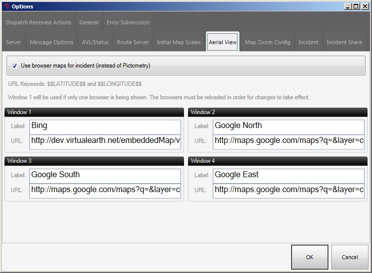
Define URLs for incident browser maps
FH Mobile Response can display oblique aerial imagery centered on an incident location. If you do not have attached Pictometry imagery, you can point FH Mobile Response to online maps from Bing Maps or street views from Google. .
Note: You must have purchased FH Mobile Response Premium to define URLs for incident browser maps in FH Mobile Response. For information on upgrading from FH Mobile Response Basic to Premium, contact your FH sales representative.
Note: The following URLs are suggestions—any URL can be used in which the latitude is replaced by the string $$LATITUDE$$ and longitude is replaced by the string $$LONGITUDE$$.
Google::
Bing:
North:
-
Choose Go → Config→ Options.
The Options dialog box appears, displaying the Server tab.
-
Click the Incident Browser Maps tab.
- Select or clear Use browser maps for incident (instead of Pictometry), whether or not to use Pictometry® imagery, or other map web sites.
- Under Browser 1, in Name, type the description or identifier that appears in the browser window label when the browser accesses the URL you specify.
-
In URL, type the URL for Bing or Google that you want to use to support the integration with online mapping of satellite or aerial views.
Warning: The URL must contain the
$LATITUDE$,$LONGITUDE$values to support the integration with online mapping of satellite or aerial views. If you specify a normal URL, the integration between FH Mobile Response and does not work. - (If necessary) Repeat steps 4–5 for Browser 2, Browser 3, and Browser 4.
- Click OK.