Survey menu
The Survey menu contains functions that let you enter the metes and bounds derived from legal descriptions.
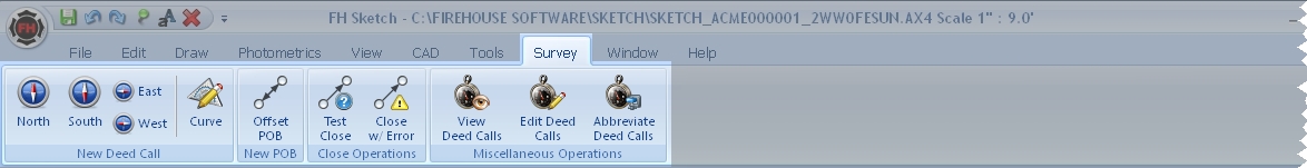
| Icon | Lets you |
|---|---|
|
|
Select a North metes and bounds call, and open the Survey Input dialog box, so that you can complete the deed call. |
|
|
Select a South metes and bounds call, and open the Survey Input dialog box, so that you can complete the deed call. |
|
|
Select an East or West metes and bounds call, and open the Survey Input dialog box, so that you can complete the deed call. |
|
|
Open the Survey Input dialog box, and prompt you for other curve data to complete the deed call. |
|
|
Draw deed calls that eventually arrive at the true POB (point of beginning), and then offset the POB to reflect where the legal description really begins. |
|
|
Report what the last deed call is to close, and check this against the legal description to verify that it matches. |
|
|
Enter the proper deed call, as it is written in the legal description, yet still close it for calculation purposes. |
|
|
Open a dialog box listing all the deed calls in the order they are drawn. |
|
|
Open a dialog box listing all the deed calls in the order they are drawn, and edit any deed call in the list. |
|
|
Show just the deed call as a bearing, without the full textual description. |


